stockport SK5 Postcodes
Spending a fortune on conveyancing?

Compare instant, low-cost online quotes from trusted conveyancing solicitors.
Backed by experts, our no-obligation service searches through the best conveyancing quotes on the market to save you time and money.
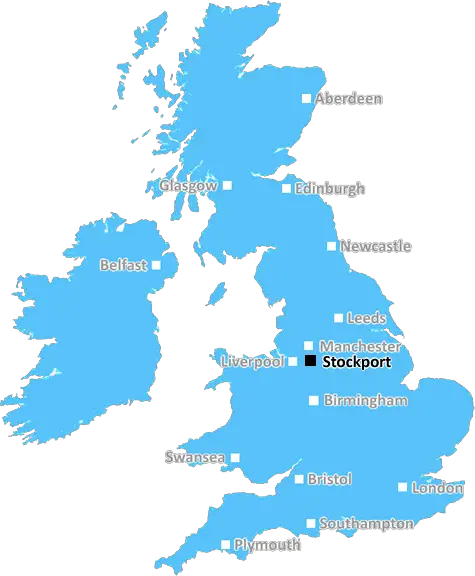
Stockport (SK5)
The SK5 postcode area is located in the Stockport postcode town region, within the county of Greater Manchester, and contains a total of 799 individual postcodes.
There are 4 electoral wards in the SK5 postcode area, including Alderley Edge, Buxton, Cheadle, Dukinfield, Glossop, High Peak, Hyde, Macclesfield, Stalybridge, Stockport, Wilmslow which come under the local authority of the Stockport Council.
Combining the whole postcode region, 13% of people in SK5 are classed as having an AB social grade, (i.e. 'white-collar' middle-upper class), compared to 27% across the UK.
This does not mean that the people of SK5 are poorer than other areas, but it may give an indication that there are areas of deprivation.
The SK5 postcode is located within the Stockport district of the borough of Stockport in Greater Manchester. It covers the areas of Reddish, Brinnington, Woodley and Bredbury.
The SK5 postcode serves a diverse residential and commercial area, with a combination of houses, apartments, and local amenities. Reddish is a large, densely populated neighborhood of terraced housing with recent expansion of houses in the area. Brinnington is a lower density residential area with large detached homes and parkland. Woodley is a suburban area with a mix of larger detached houses as well as more modest terraced housing. In Bredbury, there is a mix of residential housing, independent shops, eateries, and industrial units.
SK5 is served by a number of bus services which connect residents to nearby towns. Woodley is served by the 250 and 280 services to Stockport, Manchester, and the nearby towns of Marple and Romiley. Brinnington is served by the 250 service to Stockport, Manchester and Denton. In Reddish, there are regular bus services to Manchester and Stockport, including the 201, 204/205 and 206.
The area has a range of leisure activities including Reddish Vale Country Park, which covers over 300 acres of wildflower meadows, woodlands, streams, and ponds. Bredbury also has two parks, Victoria and Woodseaves Park. There are also a range of social clubs and sports activities in the area.
The SK5 postcode is served by several schools. All of the schools in the SK5 postcode area are rated as either 'Good' or 'Outstanding' by Ofsted. Schools in the area include All Saints Primary School in Reddish, St Albert's Primary School in Woodley, Copley Academy in Brinnington and Offerton Primary and Secondary schools in Bredbury.
SK5 is located close to a number of large shopping centres, including The Trafford Centre, Stockport Exchange, and the newly expanded Stockport Peel Centre. Stockport is also home to a range of independent shops, boutiques, and cafes, as well as a range of restaurants nearby in Bredbury, Bredbury Hall industrial Estate, and Stockport.
In terms of transport links, SK5 is located close to Mottram road and the A62, which provide direct access to Stockport, Manchester, and other nearby towns. GMPTE's hatworks bus interchange is a few miles away in Stockport, providing further connections to the rest of Greater Manchester. SK5 is also located close to the M60 motorway, making it easy to get around the region.

Demographics
Greater Manchester

SK5 is located in the county of Greater Manchester, in England.
Greater Manchester has a total population of 2,782,100, making it the 3rd largest county in the UK.
Greater Manchester has a total area of 492 square miles, and a population density of 2180 people per square kilometre. For comparison, Greater London has a density of 5,618 people/km2.
| Outward Code | SK5 |
| Postal Town | Stockport |
| MSOA Name | Stockport 003 |
| LSOA Name | Stockport 003B |
| County | Greater Manchester |
| Region | Greater Manchester |
| Country | England |
| Local Authority | Stockport |
| Area Classification | Urban with Major Conurbation |
SK5 Electoral Wards
The postal region of SK5, includes the local towns, villages, electoral wards and stations of:
Dig even deeper into the SK5 postcode by clicking on a postcode below:
Click on an outward postal code below for more information about the area. Each 'outward' postcode give you a comprehensive list of all postcodes within the outward code area (SK) and estimated address.
Click on an 'outward' code for more information. For example, the outward postcode page 'EC2M' will give you an alphabetical list covering all postcodes located in the region, from 'EC2M 1BB' through to 'EC2M 7YA'.
Chris H
Saturday, April 6, 2024
We don't have any views of SK5 right now. If you live in SK5 or have visited it, please help us to help others by telling others what you think of this neighbourhood.
Add your view of SK5
People need your local expertise. If you live in SK5 or have first-hand knowledge of the neighbourhood, please consider sharing your views. It's completely anonymous - all we ask is for your initials.
Please tell us what you like about the SK5 postcode area, what you don't like, and what it's like to live or work here.
| LOCAL AMENITIES | |
| FAMILY FRIENDLY | |
| PARKING | |
| GREEN SPACES |
From the Postcode Area blog

Deciphering Crime Rates - a Deep Dive Into UK Postcode Analysis
Ever wondered about the crime rate in your UK postcode? You're not alone. We've dug deep into the data, uncovering trends and patterns that'll make your head spin.

Death of the High Street?
The BBC reports that despite councils' attempts to kurb them, the UK's high streets have seen a huge growth in fast food outlets. Could this mark the death knell for the Great British high street, and what can we do about it to halt its decline?

Discrimination by Postcode
You really couldn't make it up, could you? Some of the country's most vulnerable people are missing out on their weekly £25 Cold Weather Payment, just because the system that's in operation is discriminating against them because payments are based on postcode, rather than geographic location.

The Redesign is Underway
Well, the current website was absolutely in dire need of a good redesign - from the ground up. So I set out to pull it all apart and get it up and running again to become the most comprehensive guide to every postcode in the UK. And it's been a long, tough job from start to finish - and quite possibly the biggest project I've ever undertaken.
SOCIAL GRADES
According to census records, 13% of people here have a social grade of AB (highest), compared to the national average of 27%.