stevenage SG2 Postcodes
Spending a fortune on conveyancing?

Compare instant, low-cost online quotes from trusted conveyancing solicitors.
Backed by experts, our no-obligation service searches through the best conveyancing quotes on the market to save you time and money.
Stevenage (SG2)
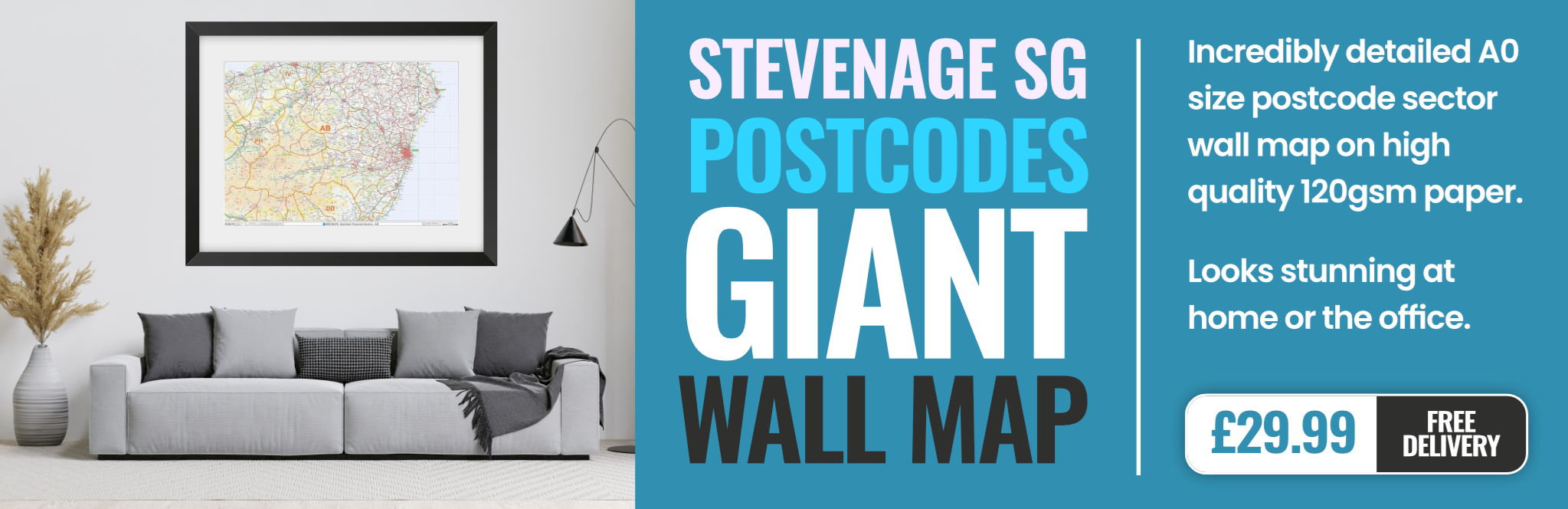
The SG2 postcode area is located in the Stevenage postcode town region, within the county of Hertfordshire, and contains a total of 1091 individual postcodes.
There are 37 electoral wards in the SG2 postcode area, including Arlesey, Baldock, Biggleswade, Buntingford, Henlow, Hertford, Hitchin, Knebworth, Letchworth Garden City, Much Hadham, Royston, Sandy, Shefford, Stevenage, Ware which come under the local authority of the Stevenage Council.
Combining the whole postcode region, 22% of people in SG2 are classed as having an AB social grade, (i.e. 'white-collar' middle-upper class), compared to 27% across the UK.
This does not mean that the people of SG2 are poorer than other areas, but it may give an indication that there are areas of deprivation.
SG2 is a postcode situated in the Stevenage district of Hertfordshire, England. It covers 11.10 square kilometres and is located in the centre of the town, with the postcode area taking in the town centre and a densely populated residential area. SG2 includes the business centre, departments of the shopping centre, the Town Square, the central public parks and playgrounds, and a section of the industrial estate.
The area is served by a large number of local amenities, like libraries and leisure centres, plenty of shops, cafes, and restuarants. There are also parks and playing fields, and a local outdoor swimming pool. Primary and Secondary schools can be found in this area, such as Knellswood Primary, Thomas Alleyne's High and The Nobel School.
Stevenage Borough Council's offices are located in the Postcode. There is an industrial estate here as well, which serves various businesses, including distribution centres, fabrication factories, engineering, and construction companies. There are also two railway stations close to the SG2 postcode area - Stevenage Railway Station and Stevenage North Railway Station.
The area sees high levels of traffic, and is not in a Low Emission Zone. It is not a very green area, and there are no cyclist lanes or paths. Property prices are just above the national average, and the populations are highly diverse. The average house price in the post code is around �393,500.
TheSG2 postcode is a thriving and vibrant area in the Stevenage district of Hertfordshire. It has a great range of leisure activities, plenty of shops and businesses, plenty of schooling options, and a diverse population. It is within easy reach of the motorway network and has good public transport links.

Demographics
Hertfordshire

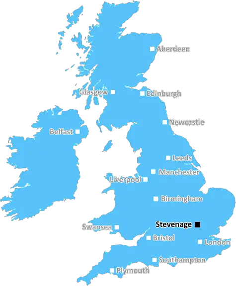
SG2 is located in the county of Hertfordshire, in England.
Hertfordshire has a total population of 1,176,700, making it the 12th largest county in the UK.
Hertfordshire has a total area of 634 square miles, and a population density of 716 people per square kilometre. For comparison, Greater London has a density of 5,618 people/km2.
| Outward Code | SG2 |
| Postal Town | Stevenage |
| MSOA Name | Stevenage 007 |
| LSOA Name | Stevenage 007D |
| County | Hertfordshire |
| Region | Hertfordshire |
| Country | England |
| Local Authority | Stevenage |
| Area Classification | Unclassified |
SG2 Electoral Wards
The postal region of SG2, includes the local towns, villages, electoral wards and stations of:
Dig even deeper into the SG2 postcode by clicking on a postcode below:
Click on an outward postal code below for more information about the area. Each 'outward' postcode give you a comprehensive list of all postcodes within the outward code area (SG) and estimated address.
Click on an 'outward' code for more information. For example, the outward postcode page 'EC2M' will give you an alphabetical list covering all postcodes located in the region, from 'EC2M 1BB' through to 'EC2M 7YA'.
Chris H
Saturday, April 6, 2024
We don't have any views of SG2 right now. If you live in SG2 or have visited it, please help us to help others by telling others what you think of this neighbourhood.
Add your view of SG2
People need your local expertise. If you live in SG2 or have first-hand knowledge of the neighbourhood, please consider sharing your views. It's completely anonymous - all we ask is for your initials.
Please tell us what you like about the SG2 postcode area, what you don't like, and what it's like to live or work here.
| LOCAL AMENITIES | |
| FAMILY FRIENDLY | |
| PARKING | |
| GREEN SPACES |
Local News Hertfordshire
Four-year-old girl and mum missing, say police
The pair were last seen at their home in February and have links to Birmingham, police say.
BBC NewsSchools to close for two days due to Big Weekend
A trust says teaching will be moved online except for GCSE students, who must attend for exams.
BBC NewsDJ Greg James apologises for glass eye comment
James and Chris Smith say sorry for saying a glass eye would make a book character "more revolting".
BBC NewsBloomfield 'proud' as Wycombe prepare for Wembley
Wycombe Wanderers could win their first trophy as a professional club on Sunday
BBC NewsPrivate ambulance service aims to reduce NHS waits
It charges users to call a healthcare professional to their home for urgent but non-emergency cases.
BBC NewsRegion faces rail strike disruption
Industrial action will take place across five days affecting the Greater Anglia network.
BBC NewsRazed speedway track cannot be revived - developers
East Herts Council is looking at "resolving planning breaches" at a former speedway racing venue.
BBC NewsMan arrested in 16,000 phone fraud probe
At least three people are talked into sending parcels of cash through the post.
BBC NewsFrom the Postcode Area blog

Deciphering Crime Rates - a Deep Dive Into UK Postcode Analysis
Ever wondered about the crime rate in your UK postcode? You're not alone. We've dug deep into the data, uncovering trends and patterns that'll make your head spin.

Death of the High Street?
The BBC reports that despite councils' attempts to kurb them, the UK's high streets have seen a huge growth in fast food outlets. Could this mark the death knell for the Great British high street, and what can we do about it to halt its decline?

Discrimination by Postcode
You really couldn't make it up, could you? Some of the country's most vulnerable people are missing out on their weekly £25 Cold Weather Payment, just because the system that's in operation is discriminating against them because payments are based on postcode, rather than geographic location.

The Redesign is Underway
Well, the current website was absolutely in dire need of a good redesign - from the ground up. So I set out to pull it all apart and get it up and running again to become the most comprehensive guide to every postcode in the UK. And it's been a long, tough job from start to finish - and quite possibly the biggest project I've ever undertaken.
SOCIAL GRADES
According to census records, 22% of people here have a social grade of AB (highest), compared to the national average of 27%.