southend-on-sea SS0 Postcodes
Spending a fortune on conveyancing?

Compare instant, low-cost online quotes from trusted conveyancing solicitors.
Backed by experts, our no-obligation service searches through the best conveyancing quotes on the market to save you time and money.
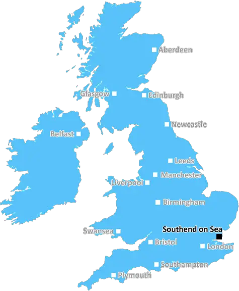
Southend On Sea (SS0)
The SS0 postcode area is located in the Southend On Sea postcode town region, within the county of Essex, and contains a total of 1103 individual postcodes.
There are 1 electoral wards in the SS0 postcode area, including Basildon, Benfleet, Canvey Island, Hockley, Leigh-On-Sea, Rayleigh, Rochford, Southend-On-Sea, Stanford-Le-Hope, Westcliff-On-Sea, Wickford which come under the local authority of the Southend-on-Sea Council.
Combining the whole postcode region, 20% of people in SS0 are classed as having an AB social grade, (i.e. 'white-collar' middle-upper class), compared to 27% across the UK.
This does not mean that the people of SS0 are poorer than other areas, but it may give an indication that there are areas of deprivation.
The SS0 postcode district is an area in the borough of Southend-on-Sea, Essex, in the south-east of England. Situated in the coastal region of the county, it has a population of over 40,000 people, and covers an area of 6.2 square miles.
The area is covered by the Westcliff-on-Sea and Southend-on-Sea local government districts, and contains the suburbs of Prittlewell, Southchurch, Chalkwell, Westcliff, Leigh, Hadleigh, and Eastwood. It is located north of the Thames Estuary and south of London.
The postcode district is served by the A127 road, as well as the railway station of Southend Victoria on the c2c line. The area is also easily accessible via the London underground network, with C2C trains taking passengers from Charing Cross to Southend Central in 90 minutes (via Upminster).
The nearby Southend Airport is the longest pleasure pier in the world, measuring 1.34 miles long. It is home to Adventure Island amusement park, which features over 50 rides and attractions. Other landmarks in the area include Belfairs Wood, Hadleigh Castle, Prittlewell Priory, and Southchurch Hall.
In terms of education, the area contains Southend High School for Boys, Southend High School for Girls, Shoeburyness High School, and Westcliff High School for Boys. The University of Essex also has a campus in nearby Southend-on-Sea.
The area is a popular destination for tourism, with attractions such as Cliff's Pavilion, a 1920s theatre, the Kursaal entertainment complex, the Beecroft Art Gallery, and several shopping centres. There are also several waterfront cafes, bars, and restaurants offering international cuisine.
The area boasts a strong retail economy, with several independent stores, a local market, and several major retail chains. It has excellent transport links, making it a great place to live, work, and explore.

Demographics

Essex

SS0 is located in the county of Essex, in England.
Essex has a total population of 1,802,200, making it the 7th largest county in the UK.
Essex has a total area of 1417 square miles, and a population density of 491 people per square kilometre. For comparison, Greater London has a density of 5,618 people/km2.
| Outward Code | SS0 |
| Postal Town | Southend On Sea |
| MSOA Name | Southend-on-Sea 005 |
| LSOA Name | Southend-on-Sea 005C |
| County | Essex |
| Region | Essex |
| Country | England |
| Local Authority | Southend-on-Sea |
| Area Classification | Urban with City and Town |
SS0 Electoral Wards
The postal region of SS0, includes the local towns, villages, electoral wards and stations of:
Dig even deeper into the SS0 postcode by clicking on a postcode below:
Click on an outward postal code below for more information about the area. Each 'outward' postcode give you a comprehensive list of all postcodes within the outward code area (SS) and estimated address.
Click on an 'outward' code for more information. For example, the outward postcode page 'EC2M' will give you an alphabetical list covering all postcodes located in the region, from 'EC2M 1BB' through to 'EC2M 7YA'.
TB, Westcliff on Sea
Wednesday, November 7, 2018
Plenty of local shops, restaurants and pubs within walking distance of the house. Residents are a mix of young and old, although there aren't that many young families who live here. Lots of commuters who work in London. You find that most people head into Southend on Sea for a night out, or further afield to Basildon or Brentwood. Easy access to lots of family activities, including beaches, Adventure Island theme park, Southchurch Park and Prittlewell Priory. A few anti-social behavioural problems but nothing that would cause concern.
CH, Southend-on-sea
Tuesday, October 9, 2018
I lived in Westcliff on Sea for a few years, and found it to be quite rough in areas, especially along the main high street at night. However, it's handy to get into Southend - you can actually walk it if you're feeling fit, or the train station is just a short walk away from Westcliff High Street. Plenty of restaurants, shops and convenience stores nearby. Great place to commute into London, although parking can be a nightmare.
Add your view of SS0
People need your local expertise. If you live in SS0 or have first-hand knowledge of the neighbourhood, please consider sharing your views. It's completely anonymous - all we ask is for your initials.
Please tell us what you like about the SS0 postcode area, what you don't like, and what it's like to live or work here.
| LOCAL AMENITIES | |
| FAMILY FRIENDLY | |
| PARKING | |
| GREEN SPACES |
Local News Essex
Rochford butcher's shop once guarded by man with a gun
BUTCHER'S shops are sadly few and far between these days, as shoppers have switched to more convenient supermarkets over the last 50 years
The EchoChafford Hundred 'firearm seen' in car close to Lakeside
REPORTS of a firearm seen in a car near a Sainsbury's superstore sparked a police chase yesterday
The EchoM25 to be closed for 8 hours as abnormal load leaves Tilbury
Essex motorists are being warned to plan their journey ahead of a huge 'abnormal load' set to travel from Tilbury to Bedfordshire today
The EchoA12 police stop: Two charged with human trafficking offences
Two people are charged with Class A drugs and human trafficking offences in Essex
Daily GazetteReview of 'wonderful' Beth Chatto Gardens in March
My review of Beth Chatto Gardens
Daily GazetteWitham Christina Road: man found seriously injured
A MANfound seriously injured after reports he had been hit by a car has sparked a police appeal for witnesses
Daily GazetteEssex woman Diane Jones murder to be explored in Channel 5 show
A Channel 5 show, Prime Suspect: Murder in Suburbia, will examine the murder of Diane Jones
Daily GazetteMixed-use London freehold to lead Allsop's March residential auction
Thefreeholdbuilding in Hampstead is guided at 2.5m-plus.
Property WeekFrom the Postcode Area blog

Deciphering Crime Rates - a Deep Dive Into UK Postcode Analysis
Ever wondered about the crime rate in your UK postcode? You're not alone. We've dug deep into the data, uncovering trends and patterns that'll make your head spin.

Death of the High Street?
The BBC reports that despite councils' attempts to kurb them, the UK's high streets have seen a huge growth in fast food outlets. Could this mark the death knell for the Great British high street, and what can we do about it to halt its decline?

Discrimination by Postcode
You really couldn't make it up, could you? Some of the country's most vulnerable people are missing out on their weekly £25 Cold Weather Payment, just because the system that's in operation is discriminating against them because payments are based on postcode, rather than geographic location.

The Redesign is Underway
Well, the current website was absolutely in dire need of a good redesign - from the ground up. So I set out to pull it all apart and get it up and running again to become the most comprehensive guide to every postcode in the UK. And it's been a long, tough job from start to finish - and quite possibly the biggest project I've ever undertaken.
SOCIAL GRADES
According to census records, 20% of people here have a social grade of AB (highest), compared to the national average of 27%.