salisbury SP7 Postcodes
Spending a fortune on conveyancing?

Compare instant, low-cost online quotes from trusted conveyancing solicitors.
Backed by experts, our no-obligation service searches through the best conveyancing quotes on the market to save you time and money.
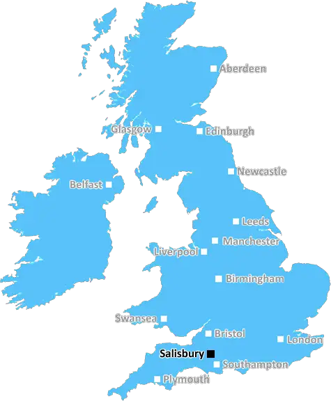
Salisbury (SP7)
The SP7 postcode area is located in the Salisbury postcode town region, within the county of Dorset, and contains a total of 757 individual postcodes.
There are 66 electoral wards in the SP7 postcode area, including Andover, Fordingbridge, Gillingham, Salisbury, Shaftesbury, Tidworth which come under the local authority of the North Dorset Council.
Combining the whole postcode region, 26% of people in SP7 are classed as having an AB social grade, (i.e. 'white-collar' middle-upper class), compared to 27% across the UK.
This does not mean that the people of SP7 are poorer than other areas, but it may give an indication that there are areas of deprivation.
SP7 is a postcode district located within the SP postcode area in the United Kingdom. It covers the eastern part of the Salisbury district in the English county of Wiltshire. The SP7 postcode district is roughly rectangular in shape and covers the villages of Berwick St James, Chilmark, Clyffe Pypard, Donhead St Andrew, Donhead St Mary, Emmaus, East Knoyle, Fifield Bavant, Hurstbourne Tarrant, Little Doune, Nunton, Teffont Evias, Tisbury, Tollard Royal, Todber and Semley, Zeals, Woodyates, as well as small parts of Mere and Sedgehill.
SP7 is a predominantly rural area, with 90.3% of the postcode district's residential population being made up of detached, semi-detached, and terraced housing � all of which are typically surrounded by majestic Wiltshire scenery. Agriculture also lies at the heart of the community and is a big influence in the local economy.
The SP7 postcode district is a popular tourist destination due to its rural scenery and numerous small towns with historic charm. Sites of particular interest and natural beauty include the chalk landscape of the nearby Cranborne Chase Area of Outstanding Natural Beauty, Stourhead House and gardens, Wilton House, and Wiltshire's famous White Horses, which are located around Salisbury Plain.
Public facilities and services within the postcode district are relatively limited, with the main centre of activity being Tisbury, which is home to a range of small shops, a post office, several churches, and the thriving George and Dragon pub. Further afield, Salisbury � which lies just outside the postcode district � is well-served with supermarkets, retail parks, schools, and leisure activities.
Public transport options within the SP7 postcode district are improved by regular bus services connecting Tisbury to the nearby towns of Salisbury, Shaftesbury, and Warminster. The regular service to Salisbury provides direct access to a mainline railway station, with regular trains connecting to Cardiff, London, and many other destinations.
The postcode district also provides good links to the rest of the UK via the nearby A303, which provides regular connections to Bristol, Exeter, and beyond. In addition to this, SP7 lies close to the nearby A36, providing direct access to the A37 and M27 motorway.

Demographics
Dorset

SP7 is located in the county of Dorset, in England.
Dorset has a total population of 771,900, making it the 31st largest county in the UK.
Dorset has a total area of 1024 square miles, and a population density of 290 people per square kilometre. For comparison, Greater London has a density of 5,618 people/km2.
| Outward Code | SP7 |
| Postal Town | Salisbury |
| MSOA Name | North Dorset 005 |
| LSOA Name | North Dorset 005D |
| County | Dorset |
| Region | Dorset |
| Country | England |
| Local Authority | North Dorset |
| Area Classification | Mainly Rural (rural including hub towns >=80%) |
SP7 Electoral Wards
The postal region of SP7, includes the local towns, villages, electoral wards and stations of:
Dig even deeper into the SP7 postcode by clicking on a postcode below:
Click on an outward postal code below for more information about the area. Each 'outward' postcode give you a comprehensive list of all postcodes within the outward code area (SP) and estimated address.
Click on an 'outward' code for more information. For example, the outward postcode page 'EC2M' will give you an alphabetical list covering all postcodes located in the region, from 'EC2M 1BB' through to 'EC2M 7YA'.
Chris H
Saturday, April 6, 2024
We don't have any views of SP7 right now. If you live in SP7 or have visited it, please help us to help others by telling others what you think of this neighbourhood.
Add your view of SP7
People need your local expertise. If you live in SP7 or have first-hand knowledge of the neighbourhood, please consider sharing your views. It's completely anonymous - all we ask is for your initials.
Please tell us what you like about the SP7 postcode area, what you don't like, and what it's like to live or work here.
| LOCAL AMENITIES | |
| FAMILY FRIENDLY | |
| PARKING | |
| GREEN SPACES |
Local News Dorset
Dyche 'responsible' as Everton match winless club record
Everton slump to a club record-equalling 12th consecutive Premier League game without a win as Seamus Coleman's late own goal hands the points to Bournemouth.
BBC NewsCliff cameras to probe missing puffins mystery
Scientists believe nesting puffins on south coast of England failed to raise chicks to maturity.
BBC NewsTrain strikes: How will you be affected?
Rail workers at 16 companies are taking industrial action but tube strikes have been called off.
BBC NewsTeenager given nine years in custody for stabbing
Thomas Betteridge was cleared of murder after claiming self-defence but convicted of manslaughter.
BBC NewsLambs stolen from farm reunited with owners
The two blue Texel lambs were two and three weeks old when they were taken from their farm.
BBC NewsBournemouth mount stunning comeback to beat Luton
Bournemouth produce one of the greatest Premier League comebacks as they recover from 3-0 down to beat Luton in a seven-goal thriller at Vitality Stadium.
BBC NewsDorset Big Picture: Friday's image of the county
Showcasing the best images sent to us from around Dorset.
BBC NewsDraw against Sheff Utd 'not a good result for us - Iraola
Bournemouth boss Andoni Iraola says that coming away with a point against struggling Sheffield United is "not a good result" following their 2-2 draw in the Premier League.
BBC NewsFrom the Postcode Area blog

Deciphering Crime Rates - a Deep Dive Into UK Postcode Analysis
Ever wondered about the crime rate in your UK postcode? You're not alone. We've dug deep into the data, uncovering trends and patterns that'll make your head spin.

Death of the High Street?
The BBC reports that despite councils' attempts to kurb them, the UK's high streets have seen a huge growth in fast food outlets. Could this mark the death knell for the Great British high street, and what can we do about it to halt its decline?

Discrimination by Postcode
You really couldn't make it up, could you? Some of the country's most vulnerable people are missing out on their weekly £25 Cold Weather Payment, just because the system that's in operation is discriminating against them because payments are based on postcode, rather than geographic location.

The Redesign is Underway
Well, the current website was absolutely in dire need of a good redesign - from the ground up. So I set out to pull it all apart and get it up and running again to become the most comprehensive guide to every postcode in the UK. And it's been a long, tough job from start to finish - and quite possibly the biggest project I've ever undertaken.
SOCIAL GRADES
According to census records, 26% of people here have a social grade of AB (highest), compared to the national average of 27%.