plymouth PL31 Postcodes
Spending a fortune on conveyancing?

Compare instant, low-cost online quotes from trusted conveyancing solicitors.
Backed by experts, our no-obligation service searches through the best conveyancing quotes on the market to save you time and money.
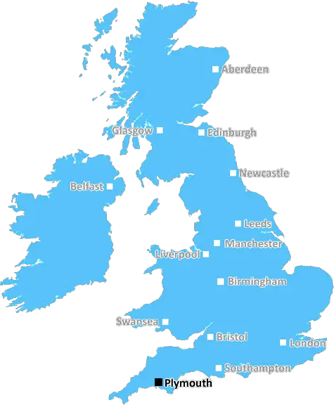
Plymouth (PL31)
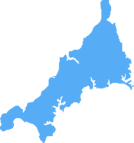
The PL31 postcode area is located in the Plymouth postcode town region, within the county of Cornwall, and contains a total of 534 individual postcodes.
There are 7 electoral wards in the PL31 postcode area, including Bodmin, Boscastle, Callington, Calstock, Camelford, Delabole, Fowey, Gunnislake, Ivybridge, Launceston, Lifton, Liskeard, Looe, Lostwithiel, Padstow, Par, Plymouth, Port Isaac, Saltash, St Austell, Tavistock, Tintagel, Torpoint, Wadebridge, Yelverton which come under the local authority of the Cornwall,Isles of Scilly Council.
Combining the whole postcode region, 15% of people in PL31 are classed as having an AB social grade, (i.e. 'white-collar' middle-upper class), compared to 27% across the UK.
This does not mean that the people of PL31 are poorer than other areas, but it may give an indication that there are areas of deprivation.
PL31 is a postcode district in the Plymouth area. Located in the South West of England, the PL31 postcode district covers a large area that encompasses the town of Bodmin and its immediate vicinity including St Breock, North Petherwin, Redmoor, Tregadillett, Blisland, Church Town and Temple.
The PL31 district is known for its picturesque landscape and many areas of outstanding natural beauty, such as Bodmin Moor which contains Bodmin Beacon, Brown Willy, Rough Tor and many other tors, and the Cornwall Area of Outstanding Natural Beauty. Much of the area is uncultivated and unspoilt.
The PL31 postcode district is home to a diverse range of cultural activities and events. These include the annual Camelford and Bodmin agricultural shows, popular music festivals such as East Cornwall Chamber Music Festival, Colourfest and Geddonbury, and other events such as the Port Eliot Festival.
The district is also home to a range of interesting attractions that depict its rural charm and character, such as the Eden Project and the Lost Gardens of Heligan. Nearby places of interest include Tintagel Castle, Port Isaac, Bude and Padstow.
In terms of education, the PL31 postcode district contains five primary schools: North Petherwin Primary School, St Breock Primary School, Blisland Primary School, Camelford Primary School and St Cleer Primary School. In terms of secondary education, the district is served by Wenford Bridge Academy.
In terms of transport links, the PL31 district has easy access to the A30, A38 and M5 motorways, as well as rail services connecting to Exeter, Plymouth and other destinations. The nearest airport is Newquay Airport, and regular bus services connect to local towns and cities.
The PL31 postcode district is a charming area that helps to embody the sights, smells and sounds of rural life in Cornwall. With its stunning views, vast array of attractions and wide variety of activities, it provides a great location for tourists and locals alike.

Demographics

Cornwall
PL31 is located in the county of Cornwall, in England.
Cornwall has a total population of 556,000, making it the 40th largest county in the UK.
Cornwall has a total area of 1375 square miles, and a population density of 156 people per square kilometre. For comparison, Greater London has a density of 5,618 people/km2.
| Outward Code | PL31 |
| Postal Town | Plymouth |
| MSOA Name | Cornwall 014 |
| LSOA Name | Cornwall 014D |
| County | Cornwall |
| Region | Cornwall |
| Country | England |
| Local Authority | Cornwall,Isles of Scilly |
| Area Classification | Mainly Rural (rural including hub towns >=80%) |
PL31 Electoral Wards
The postal region of PL31, includes the local towns, villages, electoral wards and stations of:
Dig even deeper into the PL31 postcode by clicking on a postcode below:
Click on an outward postal code below for more information about the area. Each 'outward' postcode give you a comprehensive list of all postcodes within the outward code area (PL) and estimated address.
Click on an 'outward' code for more information. For example, the outward postcode page 'EC2M' will give you an alphabetical list covering all postcodes located in the region, from 'EC2M 1BB' through to 'EC2M 7YA'.
Chris H
Wednesday, April 10, 2024
We don't have any views of PL31 right now. If you live in PL31 or have visited it, please help us to help others by telling others what you think of this neighbourhood.
Add your view of PL31
People need your local expertise. If you live in PL31 or have first-hand knowledge of the neighbourhood, please consider sharing your views. It's completely anonymous - all we ask is for your initials.
Please tell us what you like about the PL31 postcode area, what you don't like, and what it's like to live or work here.
| LOCAL AMENITIES | |
| FAMILY FRIENDLY | |
| PARKING | |
| GREEN SPACES |
Local News Cornwall
Next Cornwall area changing to fortnight bin collections this week
Households have been told to check their calendars
Cornwall LiveHow much your Cornwall MP has spoken up in Parliament this year
New figures reveal how much each MP has spoken in Parliament since the new year - and you can look up yours
Cornwall LiveWater company fines diverted into clean-up project
More than 2m is being put into a new fund offering grants to improve waterways.
BBC NewsPerranporth dad died after breaking ankle in fall
Paul Nicholls died in Royal Cornwall Hospital after surgery to fix a fractured ankle injury sustained in a fall
Cornwall LiveBroadband means rural homes could download a 'high-definition film in under one minute'
Gigabit-capable broadband is capable of delivering speeds up to 30 times faster than superfast connections which rely on traditional copper cables
Cornwall LiveCornwall Council refuses to say how much 'dormant' space company pays in rent after kicking out aviation museum
Cornwall Council and its airport have hidden behind a clause that allows it to refuse to provide information deemed 'commercially sensitive'
Cornwall LiveVibrant new Porthleven restaurant Cantina promises affordable street food
The owner of Amlies in Porthleven and LULA in Gwithien is behind the brand new restaurant which opened its doors just days ago
Cornwall LiveTorquay ease relegation fears with Truro City win
Financially stricken Torquay United ease their National League South relegation fears with a 2-0 win over fellow strugglers Truro City.
BBC NewsFrom the Postcode Area blog

Deciphering Crime Rates - a Deep Dive Into UK Postcode Analysis
Ever wondered about the crime rate in your UK postcode? You're not alone. We've dug deep into the data, uncovering trends and patterns that'll make your head spin.

Death of the High Street?
The BBC reports that despite councils' attempts to kurb them, the UK's high streets have seen a huge growth in fast food outlets. Could this mark the death knell for the Great British high street, and what can we do about it to halt its decline?

Discrimination by Postcode
You really couldn't make it up, could you? Some of the country's most vulnerable people are missing out on their weekly £25 Cold Weather Payment, just because the system that's in operation is discriminating against them because payments are based on postcode, rather than geographic location.

The Redesign is Underway
Well, the current website was absolutely in dire need of a good redesign - from the ground up. So I set out to pull it all apart and get it up and running again to become the most comprehensive guide to every postcode in the UK. And it's been a long, tough job from start to finish - and quite possibly the biggest project I've ever undertaken.
SOCIAL GRADES
According to census records, 15% of people here have a social grade of AB (highest), compared to the national average of 27%.