plymouth PL12 Postcodes
Spending a fortune on conveyancing?

Compare instant, low-cost online quotes from trusted conveyancing solicitors.
Backed by experts, our no-obligation service searches through the best conveyancing quotes on the market to save you time and money.
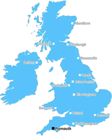
Plymouth (PL12)
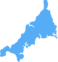
The PL12 postcode area is located in the Plymouth postcode town region, within the county of Cornwall, and contains a total of 846 individual postcodes.
There are 64 electoral wards in the PL12 postcode area, including Bodmin, Boscastle, Callington, Calstock, Camelford, Delabole, Fowey, Gunnislake, Ivybridge, Launceston, Lifton, Liskeard, Looe, Lostwithiel, Padstow, Par, Plymouth, Port Isaac, Saltash, St Austell, Tavistock, Tintagel, Torpoint, Wadebridge, Yelverton which come under the local authority of the Cornwall,Isles of Scilly Council.
Combining the whole postcode region, 24% of people in PL12 are classed as having an AB social grade, (i.e. 'white-collar' middle-upper class), compared to 27% across the UK.
This does not mean that the people of PL12 are poorer than other areas, but it may give an indication that there are areas of deprivation.
The PL12 postcode spans the urban conurbation of Saltash, a town located within the historic county of Cornwall, in the south west of England. It is part of the Plymouth postal area, a city and administrative centre of the Plymouth district.
The PL12 postcode connects the key settlements of Saltash Town, Harewood, Port Close Pill and St Stephens. These locations are serviced by various arterial roads including the A38 commuter route connecting Devon and Cornwall, the A374, and by the Tamar Bridge, which provides a direct link to Plymouth.
The PL12 postcode area has plentiful amenities and easy access to many tourist attractions including the sailing waters of Carne Beach, the Barbican area of Plymouth, the Eden Project and the waterfront attractions of the Maritime City.
The area offers numerous education opportunities for families and is serviced by The Community College Saltash, Saltash.net school, and also St Budeaux Foundation School. There are also a number of local clubs and societies that provide a variety of leisure activities, such as amateur football, basketball, rugby, golf, tennis and badminton.
The PL12 area is renowned for its picturesque natural surrounds. There are numerous parks and gardens in the area, and, the spectactular views of the Tamar Estuary and surrounding countryside provide a beautiful backdrop to the postcode. It is an ideal outdoor spot for walking, fishing and cycling.
Rich with a long history of associations to the British Royal Navy, Saltash was once a significant port and rail terminal, inspiring many of the town's traditional elements. Today, the PL12 postcode still offers an abundance of ancient character. Notable tourism spots in the area include Saltash Guildhall, which boasts several old Norman artefacts, and The Bridge Inn, an iconic local public house with roots deep in history.
The PL12 postcode area also promises a vibrant nightlife, with a selection of traditional and modern pubs, clubs and restaurants to choose from. Art galleries, theatres, shopping centres and recreational centres also feature in this bustling corner of Plymouth.

Demographics

Cornwall
PL12 is located in the county of Cornwall, in England.
Cornwall has a total population of 556,000, making it the 40th largest county in the UK.
Cornwall has a total area of 1375 square miles, and a population density of 156 people per square kilometre. For comparison, Greater London has a density of 5,618 people/km2.
| Outward Code | PL12 |
| Postal Town | Plymouth |
| MSOA Name | Cornwall 025 |
| LSOA Name | Cornwall 025A |
| County | Cornwall |
| Region | Cornwall |
| Country | England |
| Local Authority | Cornwall,Isles of Scilly |
| Area Classification | Mainly Rural (rural including hub towns >=80%) |
PL12 Electoral Wards
The postal region of PL12, includes the local towns, villages, electoral wards and stations of:
Dig even deeper into the PL12 postcode by clicking on a postcode below:
Click on an outward postal code below for more information about the area. Each 'outward' postcode give you a comprehensive list of all postcodes within the outward code area (PL) and estimated address.
Click on an 'outward' code for more information. For example, the outward postcode page 'EC2M' will give you an alphabetical list covering all postcodes located in the region, from 'EC2M 1BB' through to 'EC2M 7YA'.
CO, plymouth
Friday, November 9, 2018
Very safe and accessible neighbourhood. Excellent for access to primary and comprehensive school, bus services and a short walk to the main shopping centre (local Spar shop 2 minutes away). 5 minutes and you are in the local nature reserve with views over the rivers Tamar and Lynher.
Add your view of PL12
People need your local expertise. If you live in PL12 or have first-hand knowledge of the neighbourhood, please consider sharing your views. It's completely anonymous - all we ask is for your initials.
Please tell us what you like about the PL12 postcode area, what you don't like, and what it's like to live or work here.
| LOCAL AMENITIES | |
| FAMILY FRIENDLY | |
| PARKING | |
| GREEN SPACES |
Local News Cornwall
Inside Cornwall's 'largest and most impressive' well house
Once thought to hold the cure for whooping cough, legend has it that the well house was built on the site of a testosterone-fuelled fight to the death
Cornwall LiveFish and chip restaurant reopens after fire
The owners of the Coddy Shack on the outskirts of Looe are already planning to expand the business.
BBC NewsCornish Pirates lose to high-flying Ealing
Ealing tighten their grip on the top of Championship after winning 26-17 at Cornish Pirates.
BBC NewsLizard pub walk among most challenging in UK and more Cornwall walks for this spring
It's a six-mile coastal loop but the views are breath-taking
Cornwall LiveRCHT: Boss says things are getting better
Steve Williamson from RCHT says the picture is improving although there's more work to do
BBC NewsRNLI relay event makes its way through South West
A scroll with the RNLI pledge is passing through places of significance to the RNLI.
BBC NewsPub to close as couple 'can't make ends meet'
Customers say they are "absolutely gutted" to lose the pub and the owners will be "sadly missed".
BBC NewsTeens arrested and drugs seized as cops act on community intelligence
Officers from Devon and Cornwall Police seized around 800 in cash and a quantity of Class A & B drugs.
Cornwall LiveFrom the Postcode Area blog

Deciphering Crime Rates - a Deep Dive Into UK Postcode Analysis
Ever wondered about the crime rate in your UK postcode? You're not alone. We've dug deep into the data, uncovering trends and patterns that'll make your head spin.

Death of the High Street?
The BBC reports that despite councils' attempts to kurb them, the UK's high streets have seen a huge growth in fast food outlets. Could this mark the death knell for the Great British high street, and what can we do about it to halt its decline?

Discrimination by Postcode
You really couldn't make it up, could you? Some of the country's most vulnerable people are missing out on their weekly £25 Cold Weather Payment, just because the system that's in operation is discriminating against them because payments are based on postcode, rather than geographic location.

The Redesign is Underway
Well, the current website was absolutely in dire need of a good redesign - from the ground up. So I set out to pull it all apart and get it up and running again to become the most comprehensive guide to every postcode in the UK. And it's been a long, tough job from start to finish - and quite possibly the biggest project I've ever undertaken.
SOCIAL GRADES
According to census records, 24% of people here have a social grade of AB (highest), compared to the national average of 27%.