plymouth PL11 Postcodes
Spending a fortune on conveyancing?

Compare instant, low-cost online quotes from trusted conveyancing solicitors.
Backed by experts, our no-obligation service searches through the best conveyancing quotes on the market to save you time and money.
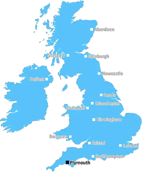
Plymouth (PL11)
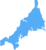
The PL11 postcode area is located in the Plymouth postcode town region, within the county of Cornwall, and contains a total of 396 individual postcodes.
There are 36 electoral wards in the PL11 postcode area, including Bodmin, Boscastle, Callington, Calstock, Camelford, Delabole, Fowey, Gunnislake, Ivybridge, Launceston, Lifton, Liskeard, Looe, Lostwithiel, Padstow, Par, Plymouth, Port Isaac, Saltash, St Austell, Tavistock, Tintagel, Torpoint, Wadebridge, Yelverton which come under the local authority of the Cornwall,Isles of Scilly Council.
Combining the whole postcode region, 18% of people in PL11 are classed as having an AB social grade, (i.e. 'white-collar' middle-upper class), compared to 27% across the UK.
This does not mean that the people of PL11 are poorer than other areas, but it may give an indication that there are areas of deprivation.
PL11 postcode is located in the Plymouth district in Devon, England. It covers the city centre and surrounding areas including, Torpoint, Saltash, St Germans, Landulph, and Tideford.
The postcode itself covers an area of approximately 42 square kilometres, with a population of circa 24,000 people. PL11 falls within the Plymouth electoral ward, which has represented the city in Parliament since 1997.
The area offers a thriving cultural scene with a dockside in the city centre, the Torpoint ferry which connects Plymouth and Cornwall, the home of the National Maritime Aquarium, and historic landmarks such as the Royal Citadel, and the Elizabethan House.
The district is well connected with good public transport services, making it a desirable area for commuters. It is also a hub for marine and manufacturing industries, providing jobs and opportunities for people living within the area.
The district further benefits from having good schools, leisure activities, and healthcare services which are essential for local residents. Additionally, PL11 boasts history in abundance, with a collection of buildings that date from the Victorian era, through to more modern architecture.
The city centre offers a mix of shops, pubs and restaurants, covering all budgets, and catering to different tastes, as well as a vibrant nightlife. Weekly markets take place, showcasing local produce and crafts, as well as specialty vendors.
Finally, the district offers a strong sense of community and togetherness - a safe and welcoming environment where people can call home. With a range of activities for all ages, and a wide selection of shops and restaurants, there is something for everyone to enjoy.

Demographics

Cornwall
PL11 is located in the county of Cornwall, in England.
Cornwall has a total population of 556,000, making it the 40th largest county in the UK.
Cornwall has a total area of 1375 square miles, and a population density of 156 people per square kilometre. For comparison, Greater London has a density of 5,618 people/km2.
| Outward Code | PL11 |
| Postal Town | Plymouth |
| MSOA Name | Cornwall 029 |
| LSOA Name | Cornwall 029A |
| County | Cornwall |
| Region | Cornwall |
| Country | England |
| Local Authority | Cornwall,Isles of Scilly |
| Area Classification | Mainly Rural (rural including hub towns >=80%) |
PL11 Electoral Wards
The postal region of PL11, includes the local towns, villages, electoral wards and stations of:
Dig even deeper into the PL11 postcode by clicking on a postcode below:
Click on an outward postal code below for more information about the area. Each 'outward' postcode give you a comprehensive list of all postcodes within the outward code area (PL) and estimated address.
Click on an 'outward' code for more information. For example, the outward postcode page 'EC2M' will give you an alphabetical list covering all postcodes located in the region, from 'EC2M 1BB' through to 'EC2M 7YA'.
Chris H
Tuesday, April 9, 2024
We don't have any views of PL11 right now. If you live in PL11 or have visited it, please help us to help others by telling others what you think of this neighbourhood.
Add your view of PL11
People need your local expertise. If you live in PL11 or have first-hand knowledge of the neighbourhood, please consider sharing your views. It's completely anonymous - all we ask is for your initials.
Please tell us what you like about the PL11 postcode area, what you don't like, and what it's like to live or work here.
| LOCAL AMENITIES | |
| FAMILY FRIENDLY | |
| PARKING | |
| GREEN SPACES |
Local News Cornwall
Porthleven Food Festival chef line-up announced including Ben Palmer from Great British Menu
You can expect plenty of celebrity chefs showing off their skills
Cornwall LiveMet Office warns of danger to life' with flood and wind warnings in Cornwall
A yellow weather warning has been issued for Monday and Tuesday
Cornwall LiveSecond phase of new rubbish service begins
Residents in south-east Cornwall are starting a new food waste, recycling and rubbish service.
BBC NewsMeet the new landlords taking 'leap of faith' with pub that closed over rising costs
The popular St Austell Brewery-owned pub was closed for six months before exchanging hands recently
Cornwall LiveMan killed in two-car crash, police say
A man in his 30s has died after a two-car crash in Cornwall, police say.
BBC NewsStorm Kathleen batters the Cornish coast
Gale force winds, high tides and large swell created sizeable waves hitting Cornwall on Saturday.
BBC NewsEvery 'act now' flood warning in Cornwall as huge waves and 75mph winds batter country
Flooding is expected across the north and south Cornwall coastlines
Cornwall LiveEaster a write-off amid wet weather, says attraction
It was a "write-off" for one fun park, as campers are told to stay away from a "saturated" campsite.
BBC NewsFrom the Postcode Area blog

Deciphering Crime Rates - a Deep Dive Into UK Postcode Analysis
Ever wondered about the crime rate in your UK postcode? You're not alone. We've dug deep into the data, uncovering trends and patterns that'll make your head spin.

Death of the High Street?
The BBC reports that despite councils' attempts to kurb them, the UK's high streets have seen a huge growth in fast food outlets. Could this mark the death knell for the Great British high street, and what can we do about it to halt its decline?

Discrimination by Postcode
You really couldn't make it up, could you? Some of the country's most vulnerable people are missing out on their weekly £25 Cold Weather Payment, just because the system that's in operation is discriminating against them because payments are based on postcode, rather than geographic location.

The Redesign is Underway
Well, the current website was absolutely in dire need of a good redesign - from the ground up. So I set out to pull it all apart and get it up and running again to become the most comprehensive guide to every postcode in the UK. And it's been a long, tough job from start to finish - and quite possibly the biggest project I've ever undertaken.
SOCIAL GRADES
According to census records, 18% of people here have a social grade of AB (highest), compared to the national average of 27%.