oldham OL12 Postcodes
Spending a fortune on conveyancing?

Compare instant, low-cost online quotes from trusted conveyancing solicitors.
Backed by experts, our no-obligation service searches through the best conveyancing quotes on the market to save you time and money.
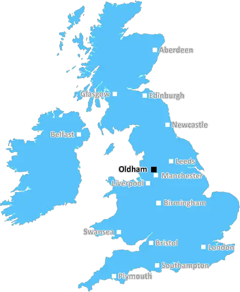
Oldham (OL12)
The OL12 postcode area is located in the Oldham postcode town region, within the county of Greater Manchester, and contains a total of 1494 individual postcodes.
There are 44 electoral wards in the OL12 postcode area, including Ashton-Under-Lyne, Bacup, Heywood, Littleborough, Oldham, Rochdale, Todmorden which come under the local authority of the Rochdale Council.
Combining the whole postcode region, 16% of people in OL12 are classed as having an AB social grade, (i.e. 'white-collar' middle-upper class), compared to 27% across the UK.
This does not mean that the people of OL12 are poorer than other areas, but it may give an indication that there are areas of deprivation.
OL12 is a postcode district covering the Oldham area in Greater Manchester, England. It is the 18th most deprived postcode district in England, according to the most recent statistical data.
The area is predominantly residential, with some light industry and local trade. The main areas within OL12 are High Crompton, Denshaw, Scouthead, Shawclough, Smallbridge and Wardle. The area has a large range of different housing types, including terraced houses, small mews cottages and larger detached properties.
The majority of residents are of working age or younger, with a significant population of families in the area. The area has a multicultural population, with strong levels of Indian and Pakistani ethnic groups. The majority of students attending local secondary schools come from White British backgrounds.
High Crompton is the main centre, with amenities such as shops and banks. Denshaw, Shawclough, Smallbridge and Wardle offer an array of smaller specialist retailers. In terms of leisure, the area offers a variety of community and park facilities, including several sports grounds and visitors' centres.
Accessibility in OL12 is excellent, with a direct rail link to Manchester and other nearby towns and cities. The M62 motorway also provides access to the wider conurbation of Greater Manchester. There are a good number of bus routes and taxi services available in and around the area, as well as a variety of private hire companies.
Crime levels in the area are relatively low in comparison to Greater Manchester as a whole, with most crimes being petty thefts and vandalism. Anti-social behaviour in the area is also recorded, but is not particularly prevalent.
OL12 is a typical area of Greater Manchester. The predominately residential area offers a range of housing choices, a multicultural and diverse population, and good levels of public transport and amenities. Crime levels are lower than average, while anti-social behaviour remains at an acceptable level.

Demographics
Greater Manchester

OL12 is located in the county of Greater Manchester, in England.
Greater Manchester has a total population of 2,782,100, making it the 3rd largest county in the UK.
Greater Manchester has a total area of 492 square miles, and a population density of 2180 people per square kilometre. For comparison, Greater London has a density of 5,618 people/km2.
| Outward Code | OL12 |
| Postal Town | Oldham |
| MSOA Name | Rochdale 005 |
| LSOA Name | Rochdale 005F |
| County | Greater Manchester |
| Region | Greater Manchester |
| Country | England |
| Local Authority | Rochdale |
| Area Classification | Urban with Major Conurbation |
OL12 Electoral Wards
The postal region of OL12, includes the local towns, villages, electoral wards and stations of:
Dig even deeper into the OL12 postcode by clicking on a postcode below:
Click on an outward postal code below for more information about the area. Each 'outward' postcode give you a comprehensive list of all postcodes within the outward code area (OL) and estimated address.
Click on an 'outward' code for more information. For example, the outward postcode page 'EC2M' will give you an alphabetical list covering all postcodes located in the region, from 'EC2M 1BB' through to 'EC2M 7YA'.
Chris H
Sunday, April 7, 2024
We don't have any views of OL12 right now. If you live in OL12 or have visited it, please help us to help others by telling others what you think of this neighbourhood.
Add your view of OL12
People need your local expertise. If you live in OL12 or have first-hand knowledge of the neighbourhood, please consider sharing your views. It's completely anonymous - all we ask is for your initials.
Please tell us what you like about the OL12 postcode area, what you don't like, and what it's like to live or work here.
| LOCAL AMENITIES | |
| FAMILY FRIENDLY | |
| PARKING | |
| GREEN SPACES |
Local News Lancashire
Critically ill boy fulfils soldier dream for a day
Noah, who is from Leyland, loves tanks and wished to be a soldier for a day.
BBC News'Arranged' gang fight causes distress for residents
Police in Burnley and Rawtenstall town centres were tackling reports of a "pre-arranged fight".
BBC NewsBritain's loudest birds are booming once again
The RSPB reports ten "booming" males at Leighton Moss - the most on the reserve since the 1990s.
BBC NewsBoy held after police officer struck by stolen car
A stolen mobility car was "deliberately driven" at an officer as he approached it, police say.
BBC NewsSteel takes 5-25 as Surrey bowl out Lancashire
Defending champions Surrey dismiss Lancashire for 202 as Cam Steel and Dan Lawrence both return career-best bowling figures.
BBC NewsWhere in the UK can you see Monday's solar eclipse?
People in the UK can also see the solar eclipse happening in the US next week
BBC NewsMosque intruder chased off after break-in
Lancashire Police say they are investigating the motive for the break-in at the mosque in Burnley.
BBC NewsCampaigners call for cemetery to be protected
They are urging a bishop to keep the site as a cemetery and stop it being redeveloped.
BBC NewsFrom the Postcode Area blog

Deciphering Crime Rates - a Deep Dive Into UK Postcode Analysis
Ever wondered about the crime rate in your UK postcode? You're not alone. We've dug deep into the data, uncovering trends and patterns that'll make your head spin.

Death of the High Street?
The BBC reports that despite councils' attempts to kurb them, the UK's high streets have seen a huge growth in fast food outlets. Could this mark the death knell for the Great British high street, and what can we do about it to halt its decline?

Discrimination by Postcode
You really couldn't make it up, could you? Some of the country's most vulnerable people are missing out on their weekly £25 Cold Weather Payment, just because the system that's in operation is discriminating against them because payments are based on postcode, rather than geographic location.

The Redesign is Underway
Well, the current website was absolutely in dire need of a good redesign - from the ground up. So I set out to pull it all apart and get it up and running again to become the most comprehensive guide to every postcode in the UK. And it's been a long, tough job from start to finish - and quite possibly the biggest project I've ever undertaken.
SOCIAL GRADES
According to census records, 16% of people here have a social grade of AB (highest), compared to the national average of 27%.