leeds LS16 Postcodes
Spending a fortune on conveyancing?

Compare instant, low-cost online quotes from trusted conveyancing solicitors.
Backed by experts, our no-obligation service searches through the best conveyancing quotes on the market to save you time and money.
Leeds (LS16)
The LS16 postcode area is located in the Leeds postcode town region, within the county of West Yorkshire, and contains a total of 1335 individual postcodes.
There are 19 electoral wards in the LS16 postcode area, including Ilkley, Leeds, Otley, Pudsey, Tadcaster, Wetherby which come under the local authority of the Leeds Council.
Combining the whole postcode region, 35% of people in LS16 are classed as having an AB social grade, (i.e. 'white-collar' middle-upper class), compared to 27% across the UK.
This does not mean that the people of LS16 are wealthier - or higher class - than average, but it can be an indication that the area may be prospering and desirable to live in.
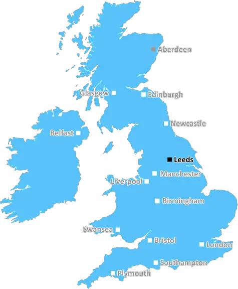
The LS16 postcode is an area of Leeds in the West Yorkshire region of the United Kingdom. It is located to the east of the city, four miles away from the centre and spans several suburbs, often referred to as �The Moorlands'. It is bordered by the LS17, LS21, LS15 and LS6 postcodes.
The area is highly residential and predominantly made up of middle-class housing estates which range from Victorian style homes to modern-built properties. It is known for its high quality of life and easy access to riverside and moorland walks. Educational facilities nearby include Cardinal Heenan Catholic High School, Moorlands Primary School and Ireland Wood Primary School. In terms of retail and leisure amenities, there are several supermarkets, including a M&S Food Hall, a variety of caf�s, pubs, shops, a cinema at the White Rose Shopping Centre and lots of green spaces. There is also a wide selection of leisure activities available - from climbing indoor walls and zorbing to outdoor sports facilities and popular fishing spots.
Transport connections in the area include several city bus routes, as well as two major locations off the A660 roundabout: Leeds Bradford Airport and the Leeds Outer Ring Road. Nearby railway stations servicing LS16 area include Horsforth, crossing over into the LS15 postcode; and New Pudsey Station, which is served primarily by services from Bradford and Wakefield.
For those looking to set up a business, LS16 postcode has plenty of office spaces and industrial units to suit any budget. There are also a number of established businesses based in the area, including the AMG Group, an established supplier of cutting edge IT solutions and services.

Demographics
West Yorkshire

LS16 is located in the county of West Yorkshire, in England.
West Yorkshire has a total population of 2,299,700, making it the 4th largest county in the UK.
West Yorkshire has a total area of 783 square miles, and a population density of 1133 people per square kilometre. For comparison, Greater London has a density of 5,618 people/km2.
| Outward Code | LS16 |
| Postal Town | Leeds |
| MSOA Name | Leeds 019 |
| LSOA Name | Leeds 019D |
| County | West Yorkshire |
| Region | West Yorkshire |
| Country | England |
| Local Authority | Leeds |
| Area Classification | Urban with Major Conurbation |
LS16 Electoral Wards
The postal region of LS16, includes the local towns, villages, electoral wards and stations of:
Dig even deeper into the LS16 postcode by clicking on a postcode below:
Click on an outward postal code below for more information about the area. Each 'outward' postcode give you a comprehensive list of all postcodes within the outward code area (LS) and estimated address.
Click on an 'outward' code for more information. For example, the outward postcode page 'EC2M' will give you an alphabetical list covering all postcodes located in the region, from 'EC2M 1BB' through to 'EC2M 7YA'.
GC, Leeds
Saturday, December 30, 2023
I live in this area. I am in West Park, I've been here for 11yrs.
Add your view of LS16
People need your local expertise. If you live in LS16 or have first-hand knowledge of the neighbourhood, please consider sharing your views. It's completely anonymous - all we ask is for your initials.
Please tell us what you like about the LS16 postcode area, what you don't like, and what it's like to live or work here.
| LOCAL AMENITIES | |
| FAMILY FRIENDLY | |
| PARKING | |
| GREEN SPACES |
Local News West Yorkshire
1970 FA Cup final: The most brutal game in English football history
As Chelsea get set to face Leeds in the FA Cup fifth round, BBC Sport looks back at the notoriously ferocious 1970 FA Cup final replay between the two sides.
BBC NewsMurder victim told police she feared ex-partner would kill her
Katie Higton warned officers of threats from Marcus Osborne, a timeline obtained by the BBC reveals.
BBC NewsDeaf team assistant condemns 'offensive' jibes
Footballers in the Leeds team are regularly mocked for having impaired hearing, Matt Dixon says.
BBC NewsFebruary 29: 'Leaplings' finally get to celebrate their birthdays
Three people in Yorkshire born on 29 February can only mark their "real" birthdays every four years.
BBC NewsRapper Ja Rule denied UK entry ahead of Cardiff gig
The musician says his criminal record was the reason he has to shelve the British leg of his tour.
BBC NewsSuper League: Leeds Rhinos 8-34 Warrington Wolves - Wire go top of table
Warrington Wolves go top of Super League with a fine second-half performance to beat Leeds Rhinos.
BBC NewsLeeds woman given terminal diagnosis after doctors missed tumour on scan
Leeds NHS trust says it is "deeply sorry" after Anne Shaw's cancer went undiagnosed for two years.
BBC NewsCounty Championship: Yorkshire take five Leicestershire wickets on rain-hit day one
George Hill takes three wickets as Yorkshire chip away at Leicestershire on a rain-hit opening day.
BBC NewsFrom the Postcode Area blog

Deciphering Crime Rates - a Deep Dive Into UK Postcode Analysis
Ever wondered about the crime rate in your UK postcode? You're not alone. We've dug deep into the data, uncovering trends and patterns that'll make your head spin.

Death of the High Street?
The BBC reports that despite councils' attempts to kurb them, the UK's high streets have seen a huge growth in fast food outlets. Could this mark the death knell for the Great British high street, and what can we do about it to halt its decline?

Discrimination by Postcode
You really couldn't make it up, could you? Some of the country's most vulnerable people are missing out on their weekly £25 Cold Weather Payment, just because the system that's in operation is discriminating against them because payments are based on postcode, rather than geographic location.

The Redesign is Underway
Well, the current website was absolutely in dire need of a good redesign - from the ground up. So I set out to pull it all apart and get it up and running again to become the most comprehensive guide to every postcode in the UK. And it's been a long, tough job from start to finish - and quite possibly the biggest project I've ever undertaken.
SOCIAL GRADES
According to census records, 35% of people here have a social grade of AB (highest), compared to the national average of 27%.