lancaster LA13 Postcodes
Spending a fortune on conveyancing?

Compare instant, low-cost online quotes from trusted conveyancing solicitors.
Backed by experts, our no-obligation service searches through the best conveyancing quotes on the market to save you time and money.
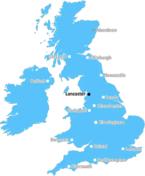
Lancaster (LA13)
The LA13 postcode area is located in the Lancaster postcode town region, within the county of Cumbria, and contains a total of 550 individual postcodes.
There are 21 electoral wards in the LA13 postcode area, including Ambleside, Askam-In-Furness, Barrow-In-Furness, Broughton-In-Furness, Carnforth, Coniston, Dalton-In-Furness, Grange-Over-Sands, Kendal, Kirkby-In-Furness, Lancaster, Millom, Milnthorpe, Morecambe, Sedbergh, Ulverston, Windermere which come under the local authority of the Barrow-in-Furness Council.
Combining the whole postcode region, 21% of people in LA13 are classed as having an AB social grade, (i.e. 'white-collar' middle-upper class), compared to 27% across the UK.
This does not mean that the people of LA13 are poorer than other areas, but it may give an indication that there are areas of deprivation.
The LA13 postcode falls in the North West England region and covers the Furness area of Cumbria. This area is already known to be a great industrial destination with scenic views and buildings to attract tourists.
LA13 postcode covers seven towns - Dalton-in-Furness, Barrow-in-Furness, Roosevelt, Roosebeck, Toupsall, Stank, and North Scale.
Barro-in-Furness is the fifteenth largest town in the United Kingdom and is often referred to as 'Barrow'. It was formed as a result of the merging of 19th century villages and being granted borough status in 1886. It used to be a key port and shipbuilding centre in Victorian times and is now home to a large variety of industries. Barrow island, part of the town, is a port that primarily serves the nuclear industry.
Other than a major industrial hub, the LA13 postcode region as a whole is relatively rural in its mixture of small villages and rural farms. Since it's a coastal destination, this region hosts millions of tourists every year, with attractions such as sandy beaches, picturesque coves and standing stones. It is especially famed for its mountainous backdrop and areas of natural beauty, including a stretch of the Lake District National Park near the town of Dalton-in-Furness.
The LA13 postcode is also known for its rare and interesting wildlife. Schools from around the North West often arrange trips here to spot the local red squirrels, otters and a variety of bird species.
To accommodate the tourists, the region is home to many hotels, guesthouses and holiday parks, as well as some of the best restaurants in the Lakes. There are also plenty of shops in the local towns, selling products from traditional local art to more modern items.
Transport is well connected for this region, with there being two train lines servicing Barrow-in-Furness and Dalton-in-Furness, as well as frequent bus services to nearby towns and cities. There are also regular ferry services running from the main port at Barrow.
TheLA13 postcode is a vibrant and diverse area that is appealing to all sorts of people for its local industry, scenic backdrop, and transport links.

Demographics
Cumbria

LA13 is located in the county of Cumbria, in England.
Cumbria has a total population of 497,900, making it the 41st largest county in the UK.
Cumbria has a total area of 2612 square miles, and a population density of 73 people per square kilometre. For comparison, Greater London has a density of 5,618 people/km2.
| Outward Code | LA13 |
| Postal Town | Lancaster |
| MSOA Name | Barrow-in-Furness 003 |
| LSOA Name | Barrow-in-Furness 003E |
| County | Cumbria |
| Region | Cumbria |
| Country | England |
| Local Authority | Barrow-in-Furness |
| Area Classification | Urban with Significant Rural (rural including hub towns 26-49%) |
LA13 Electoral Wards
The postal region of LA13, includes the local towns, villages, electoral wards and stations of:
Dig even deeper into the LA13 postcode by clicking on a postcode below:
Click on an outward postal code below for more information about the area. Each 'outward' postcode give you a comprehensive list of all postcodes within the outward code area (LA) and estimated address.
Click on an 'outward' code for more information. For example, the outward postcode page 'EC2M' will give you an alphabetical list covering all postcodes located in the region, from 'EC2M 1BB' through to 'EC2M 7YA'.
Chris H
Friday, April 5, 2024
We don't have any views of LA13 right now. If you live in LA13 or have visited it, please help us to help others by telling others what you think of this neighbourhood.
Add your view of LA13
People need your local expertise. If you live in LA13 or have first-hand knowledge of the neighbourhood, please consider sharing your views. It's completely anonymous - all we ask is for your initials.
Please tell us what you like about the LA13 postcode area, what you don't like, and what it's like to live or work here.
| LOCAL AMENITIES | |
| FAMILY FRIENDLY | |
| PARKING | |
| GREEN SPACES |
Local News Lancashire
Mosque intruder chased off after break-in
Lancashire Police say they are investigating the motive for the break-in at the mosque in Burnley.
BBC NewsBones found on beach are human, police confirm
Remains washed up at Cove Road Beach in Silverdale on Sunday and police are appealing for information .
BBC NewsReform UK drops candidates over 'racist comments'
Campaign group Hope Not Hate claims it found historical derogatory tweets made two Reform candidates.
BBC NewsPolice officer hit by stolen car in hit-and-run
The officer was conducting investigations into the theft when he was hit by the car, police say.
BBC NewsSzmodics scores twice as Blackburn rout Sunderland
Blackburn Rovers hand manager John Eustace his first win in fine style to ease their relegation fears as Sunderland crumble.
BBC NewsCan Surrey be beaten as County Championship returns?
With the new County Championship season starting on Friday, can anyone prevent Surrey winning a third straight title?
BBC NewsWolves hit back to deny Burnley crucial win
Burnley miss out on a chance to boost their survival hopes as they are held to a frustrating draw by Wolves at Turf Moor.
BBC NewsMan appears in court accused of murder
Richard Chamberlain, 34, of Colne, Lancashire, died of multiple stab wounds, police said.
BBC NewsFrom the Postcode Area blog

Deciphering Crime Rates - a Deep Dive Into UK Postcode Analysis
Ever wondered about the crime rate in your UK postcode? You're not alone. We've dug deep into the data, uncovering trends and patterns that'll make your head spin.

Death of the High Street?
The BBC reports that despite councils' attempts to kurb them, the UK's high streets have seen a huge growth in fast food outlets. Could this mark the death knell for the Great British high street, and what can we do about it to halt its decline?

Discrimination by Postcode
You really couldn't make it up, could you? Some of the country's most vulnerable people are missing out on their weekly £25 Cold Weather Payment, just because the system that's in operation is discriminating against them because payments are based on postcode, rather than geographic location.

The Redesign is Underway
Well, the current website was absolutely in dire need of a good redesign - from the ground up. So I set out to pull it all apart and get it up and running again to become the most comprehensive guide to every postcode in the UK. And it's been a long, tough job from start to finish - and quite possibly the biggest project I've ever undertaken.
SOCIAL GRADES
According to census records, 21% of people here have a social grade of AB (highest), compared to the national average of 27%.